Mount St. Helens from Coldwater II observation station. USGS geologist observing. Skamania County, Washington. May 1980. Image courtesy USGS.
Well, there’s also the sheer joy of scientific discovery for its own sake – volcanoes are fascinating in their own right. They’re windows on what goes on inside this planet, they can tell us things about how the earth works in ways no other natural features can, and so we’d study them even if not a single human being would ever be inconvenienced by one. But a volcano like Mount St. Helens threatens to harm the people who built lives near it in quieter times. It presents hazards to homes and businesses, infrastructure and commerce, aviation and recreation, and it puts lives in mortal jeopardy. It can kill those close and seriously inconvenience those who might have believed they’re too far away to worry. So when a volcano like St. Helens wakes up feeling rather indisposed, prudent officials give geologists a call and then provide them with the money, equipment and resources needed to assess the threat. Continue reading “Prelude to a Catastrophe: “Our Best Judgement of Risk””→
As Super-Typhoon Haiyan moved over the central Philippines on Nov. 8 at 05:10 UTC/12:10 a.m. EDT, the MODIS instrument aboard NASA’s Aqua satellite captured this visible image. Image Credit: NASA Goddard MODIS Rapid Response Team. Caption by NASA.
Haiyan made landfall as an extremely powerful super typhoon, perhaps the strongest ever recorded at landfall, with sustained winds estimated at 195 mph (315 kph) by the Joint Typhoon Warning Center. Previously, Hurricane Camille, which struck the northern Gulf Coast in 1969, held the record with 190 mph sustained winds at landfall. After striking Samar, Haiyan quickly crossed Leyte Gulf and the island of Leyte as it cut through the central Philippines.
We’re all we’ve got, folks. One thing we know for sure as atheists: there is no help coming from above (well, not above airplanes, anyway). There’s no supernatural aid to counter the effects of a super typhoon. Just us.
As I slowly return to a life lived without nasal spray (though not without decongestants, cough syrups, mucous conquerors, and anti-itch drops for eyes that didn’t want to miss out on the Super Viral Fun*), I am finally able to return to the day when we unleashed the fruits of one month’s labor upon the world.
I shall dispense quickly with my costume, which is yer basic pirata and easy to assemble. I had most of the components to hand after many years of buckling swashes and suchlike. This year, I acquired new boots, as the old one’s toes were out, purchased a snazzy new tricorn, and retired the cutlass in favor of something a little more streamlined. I’d have gone as Captain Jack Sparrow, but since I wanted to wear the bodice I’d sewn from instructions on the internet, I opted for Captain Jackie Sparrow, his little-known yet even more piratical sister. Continue reading “El Gran Triunfo”→
There’s more to an eruptive sequence than explosions. And there are times when a distinct lack of explosions are more troubling than endless ash columns. When earthquakes continue rattling the slopes, and one of those slopes is swelling outward several feet per day, concern and caution are the only reasonable responses.
Looking south from timberline at the bulge. Immediately preceding the eruption of May 18, 1980, the bulge was growing at a rate of five feet per day. Helicopter at right. Skamania County, Washington. April 13, 1980. (Photo by Austin Post, Glaciology)
In mid-April of 1980, Mount St. Helens had seemingly gone back to sleep. The frequent phreatic eruptions ceased. The volcano steamed quietly under stormy Pacific Northwest skies. Some residents thought the show might be over, but geologists knew better. The song wasn’t done: the prima donna was taking a last deep breath. The only question was what sort of finale to expect.
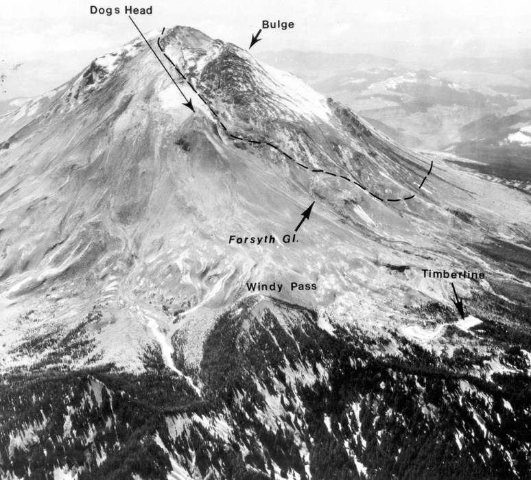
One thing was certain. That bulge they had noticed in late March was going to come down. Its failure would be spectacular. That was beyond question. It was growing too fast, over-steepening itself too much, to stay put.
Growth of the ominous bulge on the north slope of Mount St. Helens from March 29th to May 2nd, 1980. First photo of the sequence from 1964 shows her pre-eruption profile. Images courtesy USGS. Sequence compiled by Ed Klimasauskas on the Mount St. Helens Precursory Activity website.
Pause for a moment to consider the enormity of the ground deformation on that north slope: an area 1.8 kilometers (about 1 mile) long and almost 1 kilometer (about .5 mile) wide was pushing out laterally. And it wasn’t a slow change: it bulged at a rate of 1.5-2 meters (5-6.5 feet) per day. That would take a chunk of Seattle roughly from the waterfront to Interstate 5, Pike Place Market to Pioneer Square, and pop it up at least 91 meters (300 feet) in less than two months. Prop the city up vertically by around 30 degrees, add in dozens of earthquakes per day, not to mention the phreatic eruptions taking place intermittently for weeks at a time, and you have a recipe for downtown Seattle to end up heading south in a hurry. At speeds of up to 290 kilometers (180 miles) per hour, in fact. You can imagine why USGS geologist David Johnston said of the bulge on Mount St. Helens that the “only way it can stabilize is to come down.”
When you look at the area of the mountain involved, you know why Dwight Crandell and other United States Geological Survey and Forest Service officials were seriously concerned about catastrophic landslides.
Aerial view of Mount St. Helens from the northeast during the period of deformation and minor eruptions preceding the cataclysmic eruption of May 18. The area of mountain bulging to the north is outlined. Note the extensive crevassing of glaciers on this bulge. Much of the snow and ice is darkened by ash fall. Photo 80SZ-140 by David Hirst. Skamania County, Washington. May 1, 1980. Figure 5 in U.S. Geological Survey. Circular 850-D. 1981. Image courtesy USGS.
At the rate the bulge was growing, it didn’t much matter whether Mount St. Helens erupted again or not. This episode wasn’t going to end quietly.
By April 24th of 1980, the totality of the evidence gave Dr. Johnston the confidence to advise the media that it appeared magma was rising within the volcano. Studies on the bulge pointed toward a cryptodome, a thick, sticky mass of dacitic magma rising under the surface. If it had been free to squeeze out, it might have created a bump like Goat Rocks or Sugarbowl. But the old summit dome of cold, hard rock was in its way, so it remained hidden – cryptic. It pushed hard against the old dome, which stretched and split under the pressure. The summit graben – that long, linear fracture at the top – was produced this way. And the continued intrusion of the cryptodome caused the boundary between the graben and the bulge to speed northward at alarming speed: 28 feet (8.6 meters) each day. When geology moves that fast, something extreme is going on.
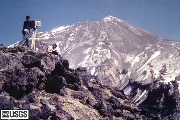
West side of Mount St. Helens, as seen from the geodimeter station Toutle Canyon. USGS Photograph taken on May 2, 1980. Image courtesy USGS.
A huge amount of deformation was taking place, but it was remarkably sharply defined. Point surveying equipment at a target set up on the bulge, and you could measure displacement in meters. Aim at a target just 488 meters (1,600 feet) to the side, and you’re down to millimeters. The south, west and east sides of the volcano hardly budged at all. The whole force of that rising magma seemed concentrated on one sweet spot.
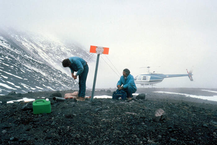
Geologists setting up reflectors on Sugar Bowl, northeast of Mount St. Helens. Skamania County, Washington. April 23, 1980. – ID. Mount St. Helens Lipman, P.W. 13ct – mlip0013 – U.S. Geological Survey – Public domain image
You can imagine that hot magma pushing so close to the surface would heat things up a bit, and you’d not be wrong. The bulge abounded with infrared anomalies, which multiplied from early April onward. At the Boot, which registered the highest temperatures, the thermal area measured a surprisingly human 37°C (98.6°F) compared to the chilly -1°C (30°F) of unaffected rocks and ice nearby. It takes a lot of heat to keep cold rock that balmy in the cold of a Cascades spring.
USGS geologist David Johnston (red circle) sampling fumarole at the crest of the “bulge”. Image taken from hovering helicopter. USGS Photograph taken on May 17, 1980, by unknown USGS photographer. Image courtesy USGS.
And a May 2nd high-resolution thermal infrared survey undertaken by personnel from the United States Navel Academy, Whidbey Island, showed things heating up further. They found new warm areas in the middle, an anomaly on the south slope of the recently-created North Peak 2 and a much stronger one on its north slope, and several anomalies in the badly fractured upper end of the Forsyth Glacier. Something not far down was awfully hot, and getting hotter.
This, combined with other indications in that ominously quiet period between April 19th and May 7th, pointed toward a spectacular end to the show. The only questions, as the mountain swelled and earthquakes continued, were up, down or both?, how big? and when?
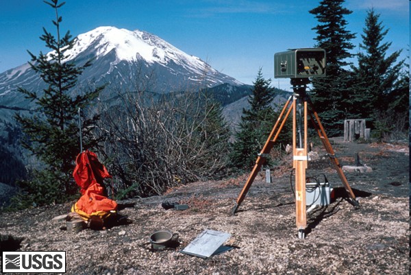
Geodimeter station (EDM) set up at Smith Creek Butte, east side of Mount St. Helens. USGS Photograph taken on April 25, 1980, by Peter Lipman. Image courtesy USGS.
What do you do when the volcano whose beauty you’ve admired for so long suddenly wakes with a shiver and blows a plume of steam and ash into the sky?
Phreatic eruption of Mount St. Helens from northwest. Skamania County, Washington. March 30, 1980. – ID. Mount St. Helens Miller, C.Dan 7ct – mmil0007 – U.S. Geological Survey – Public domain image
Thanks to Dwight Crandell and Donal Mullineaux, officials had a reasonable idea of what to expect. On March 27th, as the first phreatic eruptions fractured the summit and sent pulverized rock billowing to 2,134 meters (7,000 feet), they moved quickly to mitigate the risks. Hundreds of people living within a 24 kilometer (15 mile) radius of Mount St. Helens found themselves bundled out to safety. Pacific Power and Light, working off hazards assessments, lowered their three reservoirs on the Lewis River to accommodate expected mudflows. And geologists flocked to the mountain for the opportunity of a lifetime. It’s not often a volcano so close to major population centers gets frisky. Continue reading “Prelude to a Catastrophe: “Pale-blue Flames””→
Halloween is over, costume deadlines no longer loom, and it’s about time for me to get back to you lot. Only I got hit by a virus. It’s sort of like getting hit by a bus, only slightly less gory. I can’t dictate posts because talking hurts, and I can’t type much because all of my joints ache. It’s a bad sign when your skin rejects clothing, right? But it doesn’t appear to be super-serious, so I should be back in writing trim within the week.
In the meantime, with the government no longer shut down and the USGS photo library back online, we should be able to resume our Mount St. Helens series. I’ve also got lots of stuff to show you that I learned while making costumes: public domain audio books are a thing, so I got lots of reading done. I was on an abolition kick. It amazes me how much gets glossed over in school. My adult life has been one long series of illusions being shattered.
There are also some book reviews, and of course plenty of photos from the debut of B’s wonderful wizard costume, and some lovely fall scenery. There are huge, meaty posts full of savory rocks. And I’m sure I can manage a rant or two.
For now, though, it’s back under the covers for me. Should hair hurt? Argh.


")