
The conversation might have gone something like this:
Geologists: “Hey, boss person, we need to order vehicle parts and then destroy them. For science!”
Boss person: “Ummm… okay.”
The thing is, things happen to vehicles when they’re caught up in a directed blast. What the volcano did to them can tell us a lot about what was taking place inside that blast cloud. Vehicles in the blast zone at Mount St. Helens sustained all sorts of damage. See if you can figure out what this is without looking at the caption, which I will cleverly not put directly under the photo:

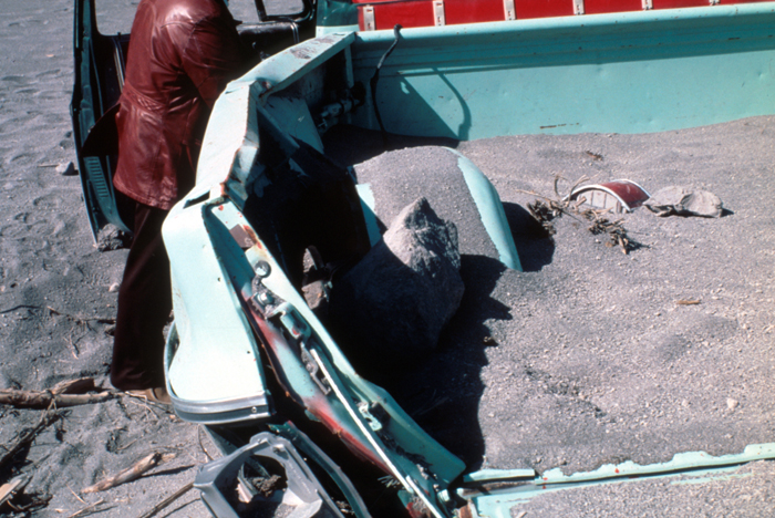
I’d say the eruption severely depreciated the value of this vehicle. If Captain Jack Sparrow were here, he’d be asking, “But why is the back seat gone?” That’s what the USGS caption says we’re looking at: “Back seat of vehicle heavily damaged by May 18 eruption, near Meta Lake 13 kilometers northeast of Mount St. Helens.” That is an ex-back seat. Still, I suppose it fared better than this poor thing, which nobody appears to be able to identify:

Note the caked-on volcanic deposits. Yum!
What happened to those vehicles tells geologists a lot about what conditions were like within that directed blast. Granted, we had eyewitnesses – stressed, terrified, traumatized, fallible human witnesses. That fallibility is why scientists turn to inanimate objects to verify and further study the effects of the eruption. These inanimate witnesses testify, too: they become part of the geologic record, and while you can’t grab a perfectly healthy person off the street and be all like, “Hey, we’re going to expose you to different levels of heat and stuff until we’re able to replicate the burns these other people suffered! Won’t that be fun?! For science!” you can certainly order some auto parts and proceed to be as volcanic as you like.
First thing before you reach for the auto parts catalog, though, is field observations. What do we see when we inspect these vehicles in the field?

I don’t think we’re going to be able to trade that one in…
The directed blast was powerful, people. So powerful that even heavy logging equipment was sometimes moved, even flipped over, by it. Geologists saw battered and scorched vehicles up to 13 kilometers (8 miles) away from St. Helens: farther out, they were “only sandblasted.” Think about this for a minute, and look at the car above, and realize that’s eight miles from the source of the explosion and there was still enough power to batter that car almost beyond recognition.
How, you might ask, did it do that? Well. Have a look at what it was hurling.
And a double-take:

Imagine the force of an explosion that can take a chunk of solid rock – and that sort of massive dacite is compact and heavy – and hurl it 6 kilometers (over 3 miles) with enough force to deform a 1980s pickup truck. In fact, Mount St. Helens heaved boulders up to 30 centimeters (about 12 inches) into vehicles. The blast wasn’t quite as powerful to the west: rocks that size only got thrown 5 kilometers (3 miles), whereas to the north, the blast cloud was able to carry them up to 15 kilometers (9 miles). Fifteen. Not rolling and bouncing them, either: they were carried at least 1.5 meters (almost 5 feet) above the ground (although a few may have been tossed up by falling trees). And if you think that’s mind-blowing, look at this:
")
What is this I don’t even.

I don’t know about the first photo, but judging from the fact the logging equipment is twisted into an unrecognizable mess, I’m going to hazard a guess that we’re well within 13 kilometers. The second photo was within 8-10 kilometers (about 4-6 miles). Amazing what a directed blast can do to heavy equipment.
So let’s see what these vehicles are testifying to, as they are now part of the geologic record.
Firstly, you wouldn’t want to be within 13 kilometers (eight miles) of the volcano during this eruption. In fact, I couldn’t track down any survivors inside that zone.
Secondly, we know that vehicles (not to mention trees, but we won’t because we’re saving those for a future installment) were overturned early. How? Because stratigraphy. Geologists saw that within 15 kilometers (9 miles), vehicles that hadn’t been flipped over had the same order of deposits they were finding on the ground. Vehicles that have been overturned also have the same stratigraphy as the ground beside them, showing that the blast cloud knocked them about in the first erosive moments, then dropped material atop them.
Sometimes lots of material. Look at Reid Blackburn’s car at Coldwater I:
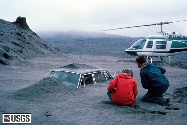
Coldwater I was actually about 13 kilometers (8 miles) away – within that zone where havoc was wreaked in earnest. The whole sequence is here, and you can see how deep it is. Geologists found that the deposits entered laterally, blown in through the windows, which had been shattered in the initial phase. There was still enough force even that far away to hurl things sideways.
(And this is where I consider the fact that Reid didn’t stand a chance, and pause for a moment to wish fiercely he’d been just a little farther away.)
That’s some pretty serious volcanic action, and we haven’t even got to the heat, and why geologists were flipping pages in automotive catalogs looking for things to destroy. We’ll hit that up in our next installment, wherein I will show you how surprisingly informative melted plastic is. Especially when scientists are set loose with some nice, fresh auto parts and a heat source or two…
Previous: The Cataclysm: “I Was Just Instantly Buried.”
Next: Interlude: What Vehicles Say About Temperatures Within a Volcanic Blast.
References:
Lipman, Peter W., and Mullineaux, Donal R., Editors (1981): The 1980 Eruptions of Mount St. Helens, Washington. U.S. Geological Survey Professional Paper 1250.
Great series, I am on the edge of my seat for each new installment. The volcano I live on exploded violently in 2006 and sent a cloud of ash+rocks+steam several miles downslope, where it met an enormous 30 ft high cement and iron rebar statue of a tree with a giant toucan and giant macaw sitting on its branches. The cement toucan, sitting on the lower branch (maybe ten feet above the original ground level) disappeared without a trace, though the broken-off branch stub still sits far above ground level. But the macaw was more interesting. It originally had a long cement tail with iron rebar inside to give it the right shape and rigidity. But the hot cloud stripped the cement off the rebar, leaving an iron skeleton, but just of the tail. The rest of the bird, higher up, is fine, hardly scratched. So the cloud was ground-hugging and not very thick.
I’m wishing for a larger version of that first logging equipment picture!
These posts are always worth a second reading.
I’m pretty sure that photo #2 is what’s left of a dashboard instrument cluster and steering column.
I’d like a closer look at the logging equipment, too.
I agree with Lithified Detritus @2. I think photo #2 is a dashboard and steering column.
I imagine taking one of those wrecks to the repair shop:
question: “What happened???”
answer: “Uhhh… volcano?”